Explore PavementAIfor Roads


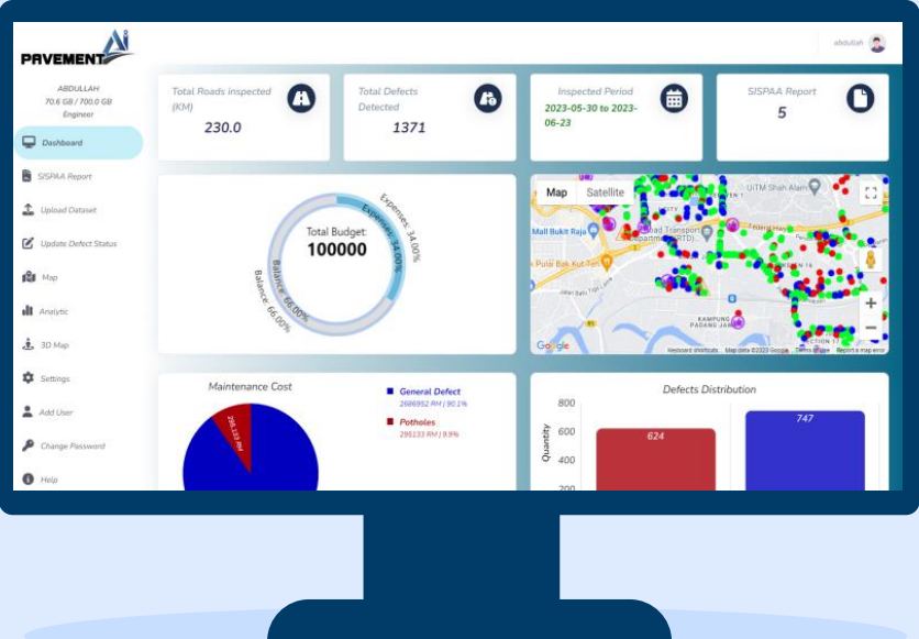
PavementAI is an Automatic Road Inspection tool, developed by Urban Explorer, using Machine Learning (ML) Algorithms. By using 360 cameras with GPS system, Images captured will be automatically analysed to detect defects, extract locations and generate reports.
The application categorizes detected cracks by type, road name, estimated maintenance cost, and other criteria based on users' requirements. Efficient and cost-effective tool for client to carry out routine road inspection, regular road monitoring and maintenance to ensure good road conditions at all time.
Urban Explorer Sdn. Bhd. is a Malaysian based company. The company was founded by two entrepreneurs with background in banking, financials, telecommunication, IT, geo-spatial, survey and mapping industry with over 30 years of combined experience in technology and product development, operations, sales and marketing. The dynamic team comprises of professionals from diverse background including Electrical & Mechanical Engineering, Software Engineering, Geomatic Science, 3D design as well as Architectural.
Where we provide services from 3D mapping and data capturing for both outdoor and indoor environment, spatial data creation and spatial applications development.
Full project life cycle management and delivery of digital twin projects.
We develop models and turn them into useful software applications that powers digital twins to provide useful functions to humans.
From conceptual design to complete database and application development.
.png)
.png)
.png)